Homiel and the Climate: Navigating the Challenges of Adaptation
Over the past thirty years, the average annual temperature has increased by 1.36 °C in Belarus. That is, three times faster than on the planet in general. Within Belarus, global warming is most pronounced in the country’s south-east, which is a more continental part. Meanwhile, cities, as systems that concentrate population and the technosphere, become most vulnerable to natural disasters. For instance, Homiel, Belarus’s second-largest city, faces some of the most severe impacts of climate change. But what steps can be taken to adapt and protect its residents? In this article, we explore the key measures to safeguard the city’s future.
ZMITSER YANKOU is an ecologist, with professional interests in urban ecology, psychogeography, green infrastructure, sustainable cities, and the adaptation of cities to climate change.
Until about the 1990s, Belarus had been clearly divided into three agro-climatic regions: Northern, Central and Southern. Subsequently, a new one emerged, where the annual sum of temperatures was 10 °C higher. This new agro-climatic region includes the Lelchitsy rayon and partially the Zhytkavichy, Bragin and Naroulya rayons of the Homiel voblast, as well as the Malaryta, Drahichyn, Luniniets and Stolin rayons of the Brest voblast. Weather conditions in this area are comparable to those in northern Ukraine. At the same time, experts claim that by 2030 the Northern agro-climatic region will be gone. The new Southern region is expanding rapidly, and an even warmer one is expected to take its place. By the period between 2040 and 2060, only a small island in the north will remain of what was once the Southern agro-climatic region (see fig. 1).

Photo 1. Changes in the agro-climatic regions of Belarus
Exploring the Adverse Impacts of Climate Change on Homiel
Primary consequences of climate change for Belarus include a rise in temperatures and an increase in the frequency of heat waves. Additionally, there is a shift in the precipitation patterns, although the average annual amount of rainfall remains the same. We are already witnessing prolonged dry periods, as well as heavy one-time rainfalls, accompanied by storms, hurricanes and causing significant harm. Alongside that, desertification of the soil heightens the risk of dust storms, particularly in dry springs, while forest fires increase the likelihood of smog.
Like most major cities, Homiel experiences the «heat island» effect, which amplifies the impact of heat waves. Especially at night, when the surfaces heated during the day keep the air temperature above +20°C.
Background: The urban «heat island» effect is a meteorological phenomenon where temperatures in urban areas are higher compared to the surrounding rural regions. It is primarily caused by significant environmental changes in the former areas, which alter various properties of the environment. For example, these are shifts in the ability to emit radiation, including changes in short- and long-wave radiation. Thermal properties also change, causing an increase in thermal capacity. Additionally, aerodynamic factors are affected, such as average wind speed, which decreases. Humidity levels can also change, including a reduction in relative humidity. The «heat island» effect intensity manifests itself most in the temperature variation between the city and its suburbs.
Analyzing Homiel’s infrared satellite images dated June 9, 2024 (see fig. 2, b), it can be noted that industrial zones are most overheated. And there, the most prominent are large manufacturing enterprises, including Centrolit, GZLiN, Chemical Plant, Selmash, and the Homiel Self-Propelled Combine Plant. The following «hot» clusters were spotted in the center: StankaHomiel-HomileKhlebPram-Kamintern, March 8-Trud, Spartak ship repair plant, Measuring Instrument Plant-CHP-1, as well as the main railway station with a car repair plant. Furthermore, relatively new residential neighborhoods are getting increasingly hot. This can be explained by the fact that they are completely devoid of vegetation. These are Melnikau Luh, Klenkausky, Khutar, and Shvedskaya Horka.
Comparing the same image with the one from June 6, 1985 (see fig. 2, a), one may note that systematic destruction of trees on the central streets has made this part of the city more prone to heating than it was in 1985. Barykina Street also stood out very vividly during this time. It evolved from being a secondary street among estate buildings into one of the largest transport arteries with multi-storey buildings built on both sides. Eventually, that resulted in changes in its temperature characteristics.
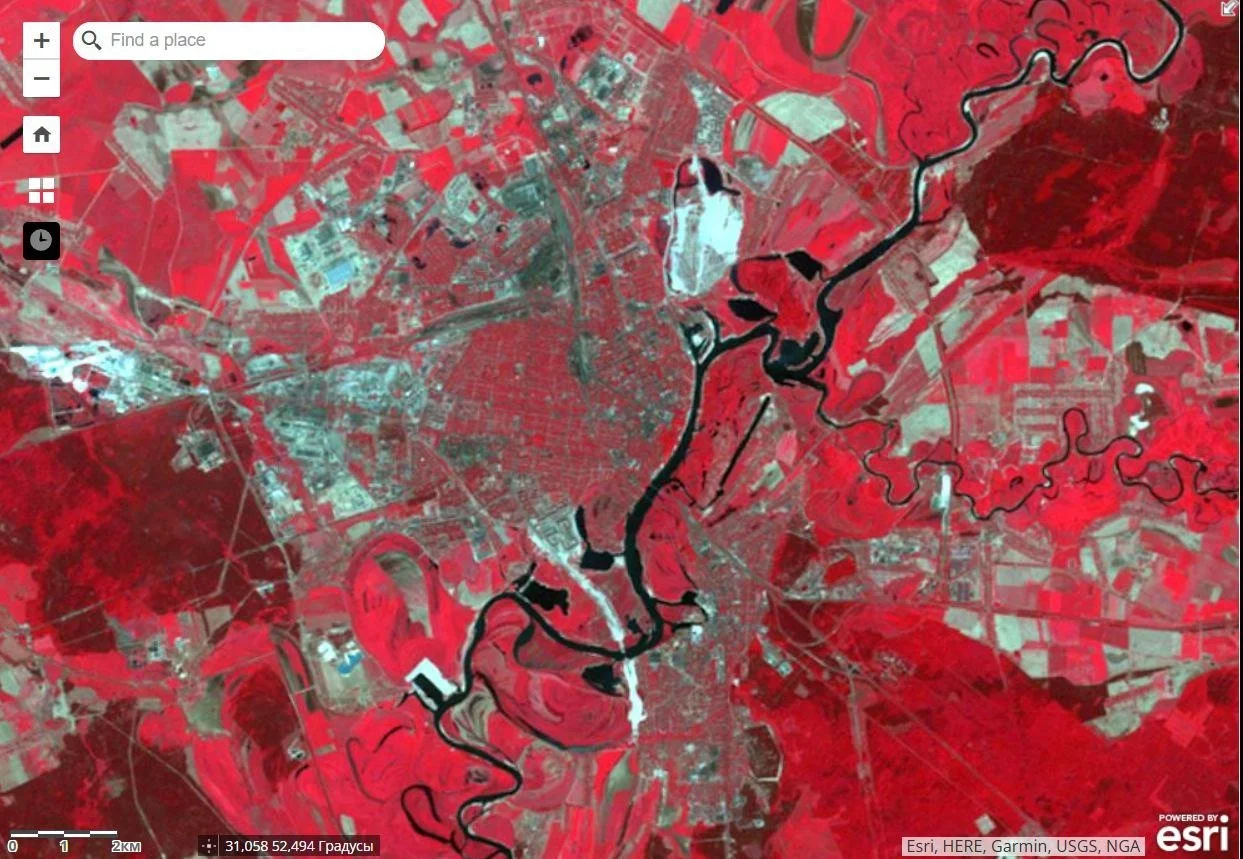


If we compare it with a map showing the spread of photosynthesis, that is, the presence of vegetation (see photo 2, c)), it can be noted that the lack of vegetation is directly related to overheating.
Besides the presence of industrial and energy facilities, which are direct sources of thermal pollution, and the lack of vegetation, surfaces with low reflectivity (albedo) also contribute to higher urban temperatures. These are primarily bitumen roofs, roads and sidewalks, as well as dark facades of buildings.
In turn, abnormal rainfall leads to flooding in certain areas and is often accompanied by strong winds. This combination can result in significant material damage and pose risks to human safety. A noteworthy observation is that flooding tends to occur in areas where streams or rivers once flowed. For example, the intersection of Savetskaya and Krylou streets, the Internatsiyanalnaya Street near Komintern, where the historic Hamiayuk river once ran, or area in the vicinity of the main bus station, where the Harelaye swamp was located a century ago. These areas are flooded during every abnormal downpour, that is, 2-3 times a year, but the city authorities do not take any significant measures to prevent flooding (see photo 3, a).
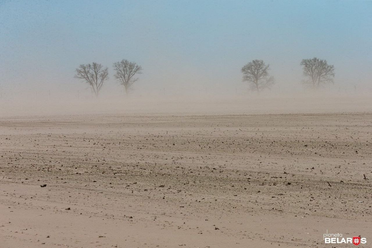
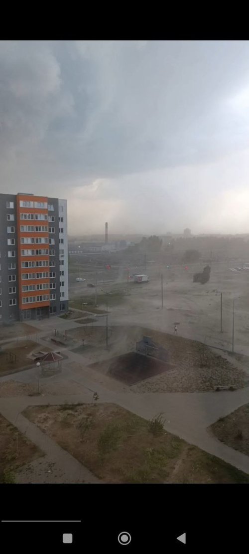
In dry springs, strong winds carry dust from nearby farmlands (see photo 3, b). Additionally, due to inadequate landscaping, these winds can create local dust storms within residential neighborhoods (see photo 3, c).

Thus, on the one hand, there are heat waves and abnormal rainfall, which are natural climatic phenomena. On the other hand, there are certain unique urban characteristics in specific areas of the city, which can amplify the negative effects of these phenomena on both public health and infrastructure to a certain extent. And while nothing can be done about natural phenomena on a city scale, urban characteristics can be changed, thereby mitigating the negative consequences.
The Effects of Adverse Weather Events on the Health of Homiel’s Residents and Infrastructure
On August 8, 2010, Homiel recorded the highest temperature ever observed in Belarus, reaching 38.9°C. It is the heat waves that most negatively affect the city residents’ health. The elderly are especially vulnerable to them, as well as hypertensive people, overweight people, children, and people with cardiovascular diseases.
For instance, in the same year 2010, in Moscow alone, heat claimed the lives of about 11 thousand people. That is about 320-340 people daily. And in 2022, about 62,000 more Europeans died in 35 countries. Italy, Spain and Germany suffered most. It is impossible to say how many citizens of Belarus pass away during the heat waves, as there are no publicly available statistics on this issue. However, comparing with data from other countries, we can definitely assume that these figures are an order of magnitude higher than those of deaths from falling trees.
Infrastructure also suffers from abnormal temperatures. The energy system takes on heavy loads from indoor air conditioning, while the asphalt pavement melts, creating «ruts». Additional funds are spent to prevent or mitigate the consequences of the above.
Damage from storms and hurricanes has its own specifics. Death and injury of people from broken trees and structures during hurricanes are hard to hide. For example, it is known that 75 people were injured and 7 died from the hurricane on July 13-14, 2024. Most of the deaths were caused by falling trees. Hence, there may be a mistaken impression that the fewer trees there are in the city, the fewer deaths there will be. It arises from the lack of information about human deaths from heat waves and a lack of understanding of the role of trees in reducing temperatures. However, we will talk about that further.
Material damage includes direct losses, such as damage to roads, electrical infrastructure, and housing, as well as flooding-related losses. Indirect losses occur from production stoppages, food spoilage due to power outages, traffic disruptions, and interruptions in business operations, among other impacts. However, similarly to heat waves, official sources do not showcase the damage caused by storms in universal units, that is, in rubles. They provide the number of localities left without electricity, torn roofs, kilometers of broken wires, etc., but the total cost of losses in rubles is impossible to find
Concealing the number of additional deaths during heat waves and the amount of material damage after adverse weather events frees the authorities from responsibility for losses that have already occurred and from the need to take measures to ensure that such losses do not occur again.
Green Infrastructure in Homiel: Structure and Potential Elements
Creating a city that is resilient to the effects of climate change has always been a complex multisectoral process that begins with accepting the very fact of climate change and the adverse effects of related weather events on the citizens’ property and health. It includes both design work and modernization of existing infrastructure facilities. Thus, adaptation of the city can be nominally divided into working with «green» and «gray» infrastructures.
Let’s take a closer look at what a «green» infrastructure is and what basic nature-based solutions are currently used to mitigate the adverse effects of climate change.
«Green» or natural infrastructure is a strategically planned network of natural territories integrated into the urban landscape, performing the following functions: microclimate-forming, mitigation (mitigating the consequences of natural emergencies), recreational, educational, and economic. Currently, experts have no doubt that the «green» infrastructure is as necessary for the city as the " gray " one, that is, water pipes, sewers, and the energy system.
To understand the vital role of nature in the city, we will explore its functions and how it enhances citizens’ comfort.
Microclimate-forming: Trees and other plants create a comfortable microclimate for citizens through cooling and humidifying the air in summer, removing harmful substances from the air, synthesizing oxygen, absorbing noise and stopping drafts.
Mitigation: During heat waves, vegetation cools the space not so much due to its shadow, but through the evaporation of moisture from the surface of its leaves. It is known that a city park reduces the temperature of the streets surrounding it by several degrees. During heavy floods, green zones take over a significant part of precipitation, and it has been experimentally proven that soil without vegetation absorbs much less water than that densely covered with vegetation. Vegetation protects soil from erosion, which preserves the road infrastructure, prevents dust storms and reduces the overall wind speed in the surface layers.
Recreation: In addition to creating a healthy microclimate, nature has a therapeutic effect on the human psyche, reducing stress and the likelihood of depression, as well as improving mood and performance.
Education: Nature enriches our understanding of the world, broadens our horizons, and reveals connections and patterns in physical and biological processes. It also fosters intellectual abilities such as creativity, critical thinking, independence, attention, analytical skills, imaginative memory, and observation.
Economics: Green areas increase the value of real estate located nearby.
The green frame or carcass, also called the environmental carcass, is considered the most effective form of urban «green» infrastructure (see photo 4).
Background: The city’s green frame or carcass is a system of green areas consisting of so-called «cores» — large arrays of green areas (forest parks, parks, squares) connected by «corridors» — the beds of urban rivers, landscaped alleys, streets with landscaping as close as possible to natural.
Photo 4. Berlin's green frame
Creation of a green frame is a complex large-scale project that requires joint effort of experts from various sectors of economy and science. However, the above can be illustrated with several examples of creation of the frame’s elements.
Thus, if landscaped properly, Kasmicheskaya street can become a corridor between the Festsevalny park and Liashchynsky forest. The square near the «Tourist» Hotel and the Old Airfield square are already connected with a corridor, the linearly elongated square of Builders along Kozhara street. The only thing left is to plant some berry bushes and perennial flowering herbs to make it even greener. Hramyka square and the Central Park area could be connected via Pushkin street, provided the street is pedestrianised and designated space is allocated for landscaping.
In developing green infrastructure to mitigate the impact of adverse weather events, the following tools are primarily employed:
Green roofs are roofs of buildings that are fully or partially covered with vegetation planted in soil. A roof filled with plants in tubs, boxes and vases cannot be called a green roof. Even trees can be planted on green stylobates, while the soil layer can be up to 1.2 m thick (see photo 5).
Photo 5. An example of a "green roof"
Such roofs reduce the load on storm sewers, significantly delaying rainwater. Additionally, they serve as effective thermal insulators, cooling the building and surrounding area during hot hours and retaining warmth in winter. Green roofs offer numerous additional benefits, such as providing noise insulation and contributing to social well-being. Those roofs are always appealing for residents to enjoy, making them ideal locations for the growth of small businesses. In England, it was estimated that 1 pound spent on green roofs returns 15 pounds in taxes from businesses that emerge there. By the way, Homiel with half a million residents cannot boast a single green roof yet. This is partly due to a lack of awareness about technologies among architects and developers.
Rain gardens are another element of urban green infrastructure and a tool for sustainable management of urban storm drains. These gardens are planted in low-lying areas designed to capture stormwater runoff from roofs, streets, and roads. Thanks to properly organized drainage and selection of moisture-loving plants from the local flora, such gardens are able not only to effectively reduce the risk of flooding in the city, but also to clean up polluted sediments flowing from city streets. Moist, densely landscaped urban areas stay cool in summer and provide an appealing space for residents to relax, which is especially important during recurring heat waves. At the same time, rain gardens form urban islands of biodiversity, attracting insects and birds (see photo 6).
Photo 6. An example of a rain garden
Rain gardens are a worldwide practice with a 40-year history. In the US, this approach is known as «Ecological Stormwater Management» (ESM) and «Low Impact Design» (LID). LID refers to environmentally conscious design techniques aimed at managing urban stormwater runoff, which can also be rendered as development with minimal environmental impact. In the UK, a similar program is called «Sustainable Drainage Systems» (SuDS), in Australia — «Water Sensitive Urban Design» (WSUD). Gardens of this kind are also common in Scandinavian countries.
In Homiel, to prevent flooding of the Savetskaya street near Skaryna University, it would be prudent to design a rain garden in the lower section of the square between Landyshau and Krylou streets. Another garden would be ideally placed in the center of the main bus station square, which frequently floods and currently features only a small, non-functional green space.
The next tool is flowering lawns, which are planted with perennial grasses native to the local flora. These can partially replace traditional mowed English lawns (see photo 7).
Photo 7. An example of flowering lawns
Unmowed lawns retain moisture more effectively, cool the surface, and incur lower maintenance costs compared to lawns that are mowed weekly. They also help the city reduce exhaust fumes and the noise from gasoline mowers, while saving on fuel and labor costs. Flowering lawns attract pollinating insects, which, in turn, are followed by birds. Finally, they are incredibly beautiful and have a therapeutic effect on city dwellers.
Restoring rivers, also known as rewilding or «the return of wildness», holds great potential as well. In most cases, small rivers and streams that fall under urban development are channeled and/or piped underground, freeing up land for roads and buildings. However, recently, a change in the understanding of comfort and attitude to citizens’ health has increased the value of having winding rivers with overgrown banks in cities compared to six-lane roads. In many European cities, the fates of urban rivers are taking new twists: they are cleared of debris, their banks are freed from concrete and planted with near-water vegetation. This results in better mitigation of temperature anomalies and more appealing vacation spots for those fleeing the heat.
Few people know, but Sozh is not the only river in Homiel. There is another one called Dzieuka. Now it is a clogged stream that flows out of the Valatouski canal and flows into Dziedna lake near the shipyard. By giving Dziuka’s riverbed a meandering shape, planting suitable vegetation, and creating running, hiking, and cycling paths along it, the area could be turned into an attractive spot for local residents. The river itself could serve as an ecological corridor, linking the Valatouski lake cascade with the Sozh river.
Finally, let us talk about urban farms. Like any other vegetation, crops partially absorb rainwater and cool the air. However, they can make an even greater contribution to urban sustainability by reducing the cost of transporting food.
The Nuts and Bolts of Adaptation
To more effectively adapt the city to new climatic conditions, technical solutions are needed alongside nature-based approaches. Buried reservoirs can be used to prevent flooding. Those reservoirs will receive stormwater during peak hours, and later this water can be utilized to water plants during dry times. Also, where appropriate, water-permeable road surfaces can be applied. These include openwork tiles on sidewalks, dirt trails in courtyards, and many more. There are technologies that allow for collecting rainwater from rooftops, which can later be used as process water within the same buildings.
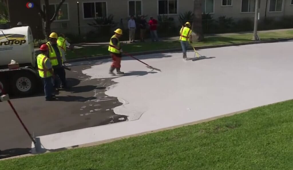
Bright colours on roofs and façades, awnings over crowded areas, reflective road paints, the installation of drinking water fountains, and misting frames, among other measures, can help mitigate the effects of heat waves (see photos 8, a and b).

The First Steps Towards Climate Resilience
The first step towards preparing cities to new climatic conditions would be acknowledgement of climate change as such. This implies focusing less on climate change globally and more on presenting localised data specific to Homiel, such as rising temperatures, more frequent heat waves, and unusual precipitation patterns. Analysis of meteorological statistics and risk assessment should be followed by identification of weaknesses in the infrastructure or the city’s climate change response system. Again, such analysis is impossible without open statistics of material and human losses during natural emergencies.
Another crucial step should be the creation of an interdisciplinary working group comprising specialists from public utilities, water management, architecture, transport, ecology, and healthcare. They are the ones who are able to assess weaknesses in their fields, where losses occur, and translate them into monetary values and human lives.
It would be ideal if adaptation measures were comprehensive, combining both nature-based solutions and various technical tools for modernising gray infrastructure.
It is vital to note once again that only careful monitoring, open statistics and public discussion will allow us to identify the most effective adaptation methods.
Every life lost due to extreme weather raises questions about whether it could have been saved and what can be done to prevent such tragedies in the future. At the same time, it is necessary to realize that climatic conditions will only get worse. The path to our city’s sustainability is challenging, but unavoidable. And the sooner the majority of Homelites understand this, the sooner we will follow it.